


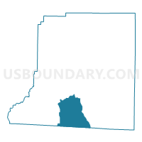
087914 - FACEVILLE Voting District, Decatur County, Georgia
About
Outline

Summary
| Unique Area Identifier | 561057 |
| Name | 087914 - FACEVILLE Voting District |
| County | Decatur County |
| State | Georgia |
| Area (square miles) | 36.75 |
| Land Area (square miles) | 36.66 |
| Water Area (square miles) | 0.09 |
| % of Land Area | 99.77 |
| % of Water Area | 0.23 |
| Latitude of the Internal Point | 30.73980270 |
| Longtitude of the Internal Point | -84.61986510 |
Maps

Graphs
Select a template below for downloading or customizing gragh for 087914 - FACEVILLE Voting District, Decatur County, Georgia


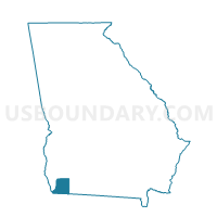
Neighbors
Neighoring Voting District (by Name) Neighboring Voting District on the Map
- 0871325 - RECOVERY Voting District, Decatur County, GA
- 0871342 - KENDRICK Voting District, Decatur County, GA
- 0871392 - FOWLSTOWN Voting District, Decatur County, GA
- 087513 - BAINBRIDGE-COLI Voting District, Decatur County, GA
- 087694 - ATTAPULGUS Voting District, Decatur County, GA
- 10-Voting District 10, Gadsden County, FL
- 13A-Voting District 13, Subprecinct A, Gadsden County, FL
- 22C-Voting District 22, N Subprecinct C, Gadsden County, FL
Top 10 Neighboring County Subdivision (by Population) Neighboring County Subdivision on the Map
- Quincy CCD, Gadsden County, FL (22,560)
- Brinson CCD, Decatur County, GA (2,799)
- Attapulgus CCD, Decatur County, GA (2,365)
- Faceville CCD, Decatur County, GA (2,035)
Top 10 Neighboring Unified School District (by Population) Neighboring Unified School District on the Map
Top 10 Neighboring State Legislative District Lower Chamber (by Population) Neighboring State Legislative District Lower Chamber on the Map
Top 10 Neighboring State Legislative District Upper Chamber (by Population) Neighboring State Legislative District Upper Chamber on the Map
Top 10 Neighboring 111th Congressional District (by Population) Neighboring 111th Congressional District on the Map
Top 10 Neighboring Census Tract (by Population) Neighboring Census Tract on the Map
- Census Tract 203, Gadsden County, FL (5,540)
- Census Tract 9702, Decatur County, GA (2,799)
- Census Tract 9708, Decatur County, GA (2,365)
- Census Tract 9707, Decatur County, GA (2,035)